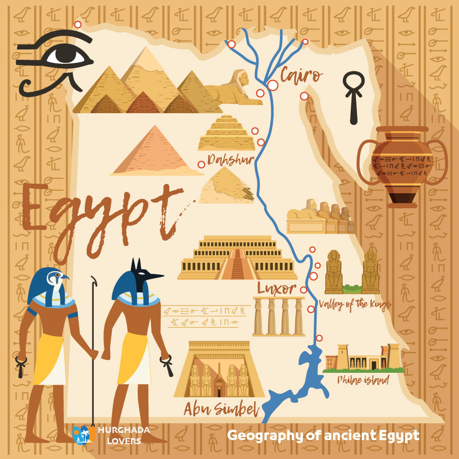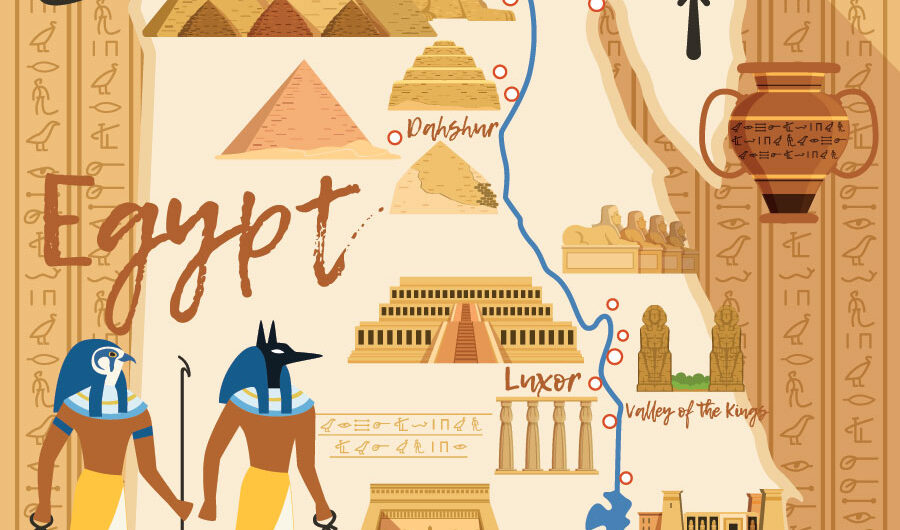
Geography of ancient Egypt | The ethnic origin of the Egyptians – Pharaohs, the facts of writing Ancient Egypt History, a complete map and the names of the regions of the Egyptian Pharaonic civilization, and more…
Facts, History, What are 5 geographical features of Pharaonic Civilization, Religion, worksheet…
Maps of borders and cities in the Pharaonic civilization, and what are the names of the upper, middle and lower Egyptian regions and cities. A table of the most important capitals in Upper Egypt, Upper Egypt, and more.
Egypt is located in the northeastern corner of the continent of Africa with the Asian Sinai Peninsula, which lies between the two branches of the Red Sea, like a triangular groove. The desert occupies 75% of the area of Hasr within the scope of the dry tropical desert region.
The Nile River runs a distance of 1536 km, currently, in Egypt from south to north, and includes about 300 islands, which are small mud islands. Today, the Nile has two branches in the delta, namely (Damietta and Rosetta), and there are coastal lakes such as (Manzala, Burullus, and Edku).
Geography of ancient Egypt
Egypt is geographically and historically a practical application of Hegel’s equation: it combines “determination” and “empathy” in a balanced and authentic “synthesis”. For this reason, we can only say that the more we analyze Husr’s personality and delve deeper into it, the more it becomes impossible for us to avoid this ending: which is that it is a “geographical slip-up” that is not repeated in any corner of the world.
In a word, the character of Egypt is sui generis, the uniqueness of Egypt, which every writer or visitor expresses in his own way and from his point of view: a special nature, an unusual topography, a unique texture, a different country.
A strange country, etc. “There is a certain truth,” writes Newby, B.H. Newby, which is that the people of Egypt are a special people, and their history has made them different from the inhabitants of any nation.
Natural Egypt consists of four sections:
- Western Desert
- Eastern desert
- delta
- Sinai
Map of ancient Egypt
Upper Egypt:
It is Upper Egypt and it is called (Upper Egypt) and it extends from the Giza region “Memphis” in the north to Aswan in the south and represents the lower part of the map of Egypt and its lands are characterized by fertility. Ancient cities in Luxor “Thebes“, Aswan, Qena, The Temple of Esna, Temple of Edfu and Tell el-Amarna.
Middle Egypt:
It is the region confined between Upper and Lower Egypt, starting from El Ayat in the north to Aswan in the south.
Lower Egypt:
It is the Nile Delta in northern Egypt and is called Lower Egypt, where the Nile splits into two branches, the Damietta branch and the Rosetta branch in the west. The area of the delta is 240 km, and its lands are arable, and its length from north to south is 160 km. It starts from the bottom near the city of Cairo now.
In the delta ten provinces and dozens of cities.
The general theory that we present in the interpretation of this slippery personality is the interaction – a coalition or a difference – between two basic dimensions in its entity, which are the site and the situation.
Dr. Ahmed Fakhry “Egyptologists” says in The Geography of Ancient Pharaonic Egypt, “Egypt derived its true personality from the personality of its land and its Nile.” As for the location, it is a relative characteristic that is determined in relation to the distributions of land, people, and production around our region, and is regulated by the spatial relationships that link it to it.
Geography of ancient Egypt. The site is a tangible internal local property, but the site is an invisible engineering idea. With these two essential elements and the changing relationship between them, we explain the character of our Egypt.
They differ when we find, for example, that the size of the site was not always commensurate with the gravity of the decisive site on the corner of the world.
There is something like a consensus that the exceptional location of Egypt and the presence of the Nile River in it were among the most important factors that made Egypt a country that embraced a great civilization to the exclusion of other neighboring countries, despite our tendency to believe that the ancient Egyptian man was the third important monarch through which this civilization emerged and crystallized.
Geography of ancient Egypt. It is also not surprising that the human cover comes from urbanization, housing, and population, more like a thick, dense, compact human precipitation that does not know any disturbance or gaps. Since the dawn of history from Predynastic Period and Naqada III, the Egypt of the valley appears as a closed tube densely populated, and the population seems to be stacked like a compact forest of people in an archipelago full of villages, villages, and cities.
Just as ancient Egypt was more populous than most of the countries of the known world and alone equaled many of them, the population density in modern Egypt is equal to or greater than that of the richest and most crowded industrialized countries.
From the natural foundation and the ground base, then, to the economic structure to the human cover and the civilizational edifice, Egypt is easily and certainly a density rather than an area, just as it is in its natural morphology a distance before it is an area; It is a crystal of definite extent, and if it is excessively extended, it is essentially infinitely intense and unrelenting.
What territories did ancient Egypt have?
A group of names for cities and powers was launched in The ancient Egyptian Pharaonic language. old ones:
- Newt is a large continental city, a village
- Gno the capital Kafr a few villages
- Hibernate Territory for small town dolls
Ancient Egypt was divided by the Egyptian Pharaohs kings into regions, which are the early geographical divisions of Egypt, as provinces that ranged between 38 and 42, as they are the first administrative borders, and these divisions remained throughout the ages of ancient Egypt and each had a capital, and these regions “Old Kingdom, Middle Kingdom, The New Kingdom” became administrative regions in the Ptolemaic era.
And for the sake of an accurate enumeration of those tribal and marine regions and their Egyptian, Greek and Latin names, their capital and their modern name, and the The Egyptian Gods in which they were worshiped, we worked on putting.
Table of geography of ancient Egypt, Upper Egypt (Upper Egypt) (regions of the south) 22 regions:
Major deities Current location Capital Greek name Egyptian name Territory | Geography of ancient Egypt.
- Khnum, Horus God Seshat, God Anuket, Abu Elephantine, Setty
- Horesh Al-Saqr, God Hathor, Ahi Edfu, Jabaa Apolloniopolis, Athos
- God Nekhbet El Kom El Ahmar Nekhen Hiracnopolis Nekhen
- Amun-Re God Mut, God Khonsu, Luxor, Thebes
- Bekoy (Ntri) Coptus Gptio God Min
- Ity Tantras Eunt Temple of Dendera Hathor, Horus
- Bat Diospolis Barqa Patio is Neferhotep, Hathor
- The Temple of Abydos Tower drape the buried godmother Amteo
- Anuris God Osiris Khenti
- Menu Panopolis Menu Chotib Maine, Harour
- Wagit Aphroditopolis Wagit Kum Ashqaw Ras, May Hasa
- Hypsilis Mercury Chott Horus Tea, Set
- Gift of Heraknopolis, Paraante, near Asyut, Horus, 12th century
- Najaf, betrayed Lyonopolis, south of Assiut, by Watt
- Najaf, Koussai betrayed the Qusiya priest Hathor
- Ono Hermopolis, guess the Ashmunein God Thoth
- Harakenbupolis, Habno, Kom al-Ahmar, Al Minya, Horus
- Enbu Kinopolis Hanno Alqais God Anubis
- Ante Hyponis on Anou Al-Hiba Anubis, sugar
- Abu Auxir Nakhos Sabt Meru Al-Bahnasa Harsaqs
- Nart Khanet Hedqliopolis Nununsut (Hanen Nsut) (Sutun Hanan) Ahnasih city Khreshev, God Khnum
- Narat Bahet Nilopolis Shena God Nut east of Abusir, Al-Malaq Hathor, Khnum
- Metnot Aphroditopolis Pride Atfih Teb Ahi Hathor
Table of Lower Egypt (Lower Egypt) (northern regions) 20 regions:
Major deities Current location Capital Greek name Egyptian name Territory
- God Ptah, Smakht Memphis Eneb-Haj Memphis Eneb-Haj
- God Horus Ossim Bar Nabt Imau Ginayokopolis Iwa
- Ibis
- Nate, Amun-Ra Zawiya Razin Jaqaa Bar Prosopis Net Rsi
- God Amun God Ra Sakha Khasu Zois Jokhasu Sa El-Hagar “Sais” in Basyoun, Gharbia
- God Isis, Horus Latif-Ra Amenti, Methlis-Ra Amenti
- Atom Tell Al-Maskhotah Theko Hieronbulps Ra Iab
- Osiris Abusir Banna Ddu (Gedu) Busiris Anat
- Horus Tell Atrebb Hout Taheri Ibb Atrebis Ka
- Horus, Anuris Herbit Eh, according to Casp Qartius, Eh, according to Casp
- Amun Ra Mut, Khonsu Samanoud, Theb Netout Spinouts, Eb Netrett
- Ra, Atum Al-Mataria Ein Sun
- On Heliopolis really Anj
- Horus, Hapi, Set San al-Hajar, Banu Tanis, Khant Eyab
- Horus, Thoth of Damanhur, Berghuti, Hermopolis, Thoth
- Khnum, Osiris Tami Al-Amid, Djed Mendes Hat Mahat
- Sabed, Horus, Ra Al-Balamon, Diospolis, Sama
- Bastet Amun-Ra Tell Bastah Bast Bubastis Amti Khenty
- Obligated Hill of the Pharaohs Bhutto
- Seped Saft Al Henna Persebedo Arabia Sepedo
Map of Geography of ancient Egypt:
The current name of the city is the Egyptian name of the capital
- bulbous cell
- Hill of the Fara’in Bhutto
- Memphis Enb Hajj (Memphis)
- Nn-Nsu, Hirakeopolis of Ihnasia
- Luxor Thebes
- Lisht Ith Tawi
- Kafr Sheikh Sakha
- San stone Tanis
- Tell el-Amarna Akhetaton
- Qantir Bar-Raameses
- The stone sawaw
- Mendes Brabant found
- Samanoud Tib Prose
- Alexandria Alexandria
Geography of ancient Egypt. The geographical documents of ancient Egypt | the facts and history of geographical achievements in the Pharaonic civilization.
discovered the geographical division of the territories of the Pharaonic era, the secrets of ancient Egyptian maps, the Pharaohs, the dismantling of the mystery of the Turin papyrus and other secrets.
The geographical records of Pharaonic Civilization are scarce, and egypt’s geographical achievements are not numerous and qualitative compared to the civilizations it believed in a field such as the Sumerians, Babylonians, and Phoenicians. We will describe the most important aspects of the geographical achievements of the ancient Egyptians:
Geographical documents of ancient Egypt – geographical division of regions:
There is no doubt that the division of Egypt into tribal and maritime territories of about 42 territories was a high-precision geographical procedure conducted by the Egyptian Governments at all stages of its ancient history. However, we do not see any geographical development of this procedure, despite the continuous geographical administrative division of regions and cities.
The few simple Egyptian maps and the papyrus of Turin:
The realization of the Egyptians in the field of mapping is not proportional to the size and type of its civilization, although ancient Egypt advanced in the field of detailed space and the use of engineering methods as in Architecture in ancient Egypt to know the area of agricultural land “Agriculture in Ancient Egypt” but did not provide mapping in these areas. We may decide that they did not know the map properly as other civilizations have known them.
Geography of ancient Egypt. The oldest thing we know about Egypt, geographically, is the Turin papyrus, called “the golden papyrus”, dating from 1320 BC., where a geographical map of the Gold in Ancient Egypt mines in the eastern desert in Wadi Hammamat is recorded, and there are gold mines in Wadi Abad in Aswan where the temple of El Radisia from King Seti I one of Egyptian Pharaohs kings “Nineteenth Dynasty of Egypt“, and many other mines surrounding this area such as the Dongash mine northeast of Samut and the Wadi Al-Houdi and Wadi Al-Alaki mines.
There is a document mentioning the names of the gold mines known to the Egyptian region Nubia, symbolizing each mine with a table of offerings, and writing the name of the mine, dating from the time of King Ramses II written on the inventory of the Luxor Temple “Egyptian Temples” and the mines mentioned as follows (from north to south):
- Jabal Qift (north of Wadi Hammamet)
- Mount Edfu (mines of Wadi Abad).
- Mountain disinfectant (Wadi Hammamet)
- Mount Khenty Hen Nefer (Central Nubia)
- Tasti Desert (Wawatt region)
- Mount Kouche (near Margarine)
- Mount Amo (between Solab and Karma)
- Thrones of the Earth (Mount Burqel)
Practical geography, city names and flood levels:
Papyrus Harris I and Wilbour Papyrus were illustrated by the names of cities from north to south, as well as lands belonging to High Priest of Amun, as well as by the levels of rising nile water during the flood earlier this year, where the white shrine of the Karnak Temple from the time of King Senusret I “Twelfth Dynasty of Egypt” included a list of Nile water levels in the flood.
Geographical documents of ancient religious Egypt by the Gohilak papyrus:
The temples and their high priests knew well the locations of the whole country, where they knew the arable land, the type of culture, its areas and access to water, as the Mortuary Temples contributed and supervised agriculture, as well as the sacred thresholds, the temples of the gods, the burial areas, and their places.
Geography of ancient Egypt. The processions of the offering campaign and the ways in which they walked and stopped were all a kind of religious geography; there were classified and specific documents of these purposes. This information was also engraved on the walls of a hiding place under the Temple of Dendera.
The Gohilak papyrus contained a detailed display of religious geography as in Ancient Egyptian religion and Egyptian Mythology. Perhaps the best example of religious geography is what he wrote (Famine Stela) about the province of The Temple of Philae, which was written in memory of what happened at the time and “in order to seek salvation from the famine that the country experienced for seven years.
Geography of ancient Egypt. The king sent a priest guided by the gods of Acheronian after his return, the priest gave him a detailed report to all who knew him in the area of the waterfall “Temple of Isis Near Old Cataract“, where data on the following things were found description of the elephants and census of their legendary names, Nile and flood, God Khoum and his recipes and titles, the surroundings, the open mountains of quarries.
A statement of the gods in the Temple of Khnum in Elephantine Island, the names of the stones that can be found in the area, as if the prophet priest had found in the library of the Achemoneine a full-fledged author on the first region of Upper Egypt, from where he drew what was extracted with ease.
As a result, we can think that each region had not only a detailed record of its legendary geography and various cultures, but also a whole special collection of these works in the most famous libraries, and certainly the knowledge of priests from foreign countries about Egypt was less detailed and less accurate.
Geographical documents of ancient Egypt – tour of the African continent:
In the 6th century B.C.C., king Necho II “Twenty-Sixth Dynasty of Egypt” carried out a project to tour the African continent with the help of Phoenician navigators, where Egyptian ships “The army in ancient Egypt” departed from the northern Red Sea and returned to Egypt via Gibraltar, a journey that lasted three years.
In other things, he discovered all the coasts of Africa and was identified on its coasts, detecting trade routes and looking for new countries with which to trade, and geographers and historians said that the navigators’ supplies were ending, so that the sailors worked to descend several times to the coast, ploughing the land, sowing the seeds and waiting until harvest, then continuing their journey, in addition to growing wheat, the navigators worked by catching many fish and hunting animals.
Geography of ancient Egypt. This was done peacefully with the inhabitants of the country where they were descending, and we come back to saying that the results at the geographical level were not excellent, because such a trip could have been a valuable treasure trove of geographical and anthropological information, but it did not happen.
Names of peoples and prisoners:
The Egyptians were particularly well aware of the peoples around them, and in the temple of Edfu, which dates back to the first century B.C, there is mention of the peoples who lived a thousand years ago, as well as the walls of the temples, as well as the invasions of neighboring countries by the Egyptian armies and the pursuit of invaders.
The texts on the pots and statues of enemies and prisoners contained lists of their names and the names of their people, Nubian, Libyan and Asian, and these statues worked for magical purposes, they believe that it will harm their owners, which gives a lot of information.
The facts about the history of writing ancient Egypt among the Pharaohs, discover the secrets of the sciences of the history of the ancient Egyptians in the Pharaonic civilization, the texts of Ramses II, Kadesh and more.
Geography of ancient Egypt. There was not a single evolutionary tendency to write the history of Pharaonic Civilization of long history; But we can consider the Papyrus as the general source of this story, which has been distributed to museums and universities around the world.
The collection of Egyptian papyri in the Austrian Public Library is the largest in the world.
The facts about the history of writing ancient Egypt
Most of it was transferred to Vienna when it was helped by archaeologist and carpet merchant Theodore Graf, who transported 10,000 papyri from Fayoum (its former name Isnoy) and Ekhnas (its former name Heracleopolis) to Vienna, and they were able to reach Prince Rainier, then the Archduke dedicated this collection to his uncle Emperor Frantz Joseph on his birthday, which he added as a special collection to the General Tsarist Library of the Austrian Empire and the Kingdom of Hungary.
Geography of ancient Egypt. Other collections were then purchased to be at their reach.
History of the Civilization of Ancient Egypt:
These Egyptian papyri tell the story of Egypt from the early dynasties First Dynasty of Egypt to the Islamic era “Islamic Egypt History” and include papyrus and paper manuscripts, pieces of pottery, leather, wood, wax plates, stone, bones, and textiles.
The most important historical papyri are the papyri that have cited tables or lists of names of kings, most of which have been lost, but there are some, including the Turin papyrus, which has cited the names of kings, which are from the time of Ramses II and were written in hieratic writing but suffer from many voids due to their poor conservation and breaks.
The second source of Egyptian historical documents is written stones such as the Palermo Stone (which relates the kings of the Fifth Dynasty of Egypt), the list of karnak, the Abydos King List and Saqqara, and the frescoes of the dates of kings, wars, events, and peoples, which are numerous.
The third source is the genealogical texts of the great Egyptian Monuments, Egyptian Antiquities, Egypt Archaeological Sites and Egyptian Tombs, their ancestors and the kings who lived with them.
Geography of ancient Egypt. We can consider the antiquities of Egypt, all of them, as a material of Egyptian civilization in all its manifestations, but the chronological history is undoubtedly limited to specific monuments that we talked about in a quick conclusion above. But we can look at the most important of these relics of Egyptian history written by the ancient Egyptians themselves in this reference.
Antiquities related to Egyptian history:
Small stellas, murders, and careers of kings:
Small stellas of stone, ivory, ebony or wood arranged in chronological order and extending their reign and the most important events of their time (pre-dynastic era, the first historical dynasties Dynasty 00 and Dynasty 0 are the most important model: the prayer of King Scorpion II).
Tables of kings:
- Stone of Palermo
- List of Sakkarah
- List of Karnak
- List of The Temple of Abydos
- Papyrus of Turin
- Genealogy Tip
Geography of ancient Egypt. Lists and accounts of kings in chronological order and durations and Their reign and the most important events of their time
A broken slab of black diorite broken into six pieces, one in Palermo, four in The Egyptian Museum “Museums in Cairo” in Tahrir Square and the sixth in the University Museum of London, Last names of reports of dynasties (58) names of kings deleted
Among them are King Akhenaton and the kings of the dynasties of the two intermediate periods. The names of the kings of the First Intermediate Period are never mentioned.
Hieroglyphic inscriptions on the walls of the temple of Karnak have been found in the Temple of Seti I, Temple Ramses II in Abydos, the first in The British Museum and the second in the temple and remembering King Narmer “Menes” to King Ramesses I, founder of the nineteenth dynasty and his son Sethi I.
Written in hieratic during the reign of Ramses II, it contains 300 names of kings and is now in the Pyrenees at the Museum of Turin in Italy.
Geography of ancient Egypt. Contains the names of 60 priests with the names of kings who lived in their time, mentioning periods of reign in years, months, days and their most important achievements and their ceremonies , wars, and business missions and Festivals in Ancient Egypt.
Lists of kings by their names and extended by kings some Dynasties -1 to 5, kings some Dynasties 1 to 19, kings of dynasties (4 at 18), reign of Thutmosis III, kings of the Dynasties (1-19), kings pre-dynastic (5-17), and senior exiles in captivity (11-22) and denied them in reverse order, that is, from the 22nd.
Legends and stories: Geography of ancient Egypt.
Legends of a gods like the legend of Osiris and Seth, stories of the sons of King Khufu, Papyrus al-Awar, the story of Malukhi, the assassination attempt of Amenophis I. Its atmosphere gives us an idea of its historical era.
The facts about the history of writing ancient Egypt and historian Manetho:
Writing (History of Egypt) commissioned by King Ptolemy I. Fragments, which included the section of the dynasty, burned, and remained, an Egyptian historian who lived in hellenistic times (323-245) B.C., from Sebenitos in the delta of Egypt.
Manetho was an Egyptian-Greek priest and historian born in the delta in Sebenitos, living in the time of Ptolemy I, and wrote an important book on Egypt in Greek, collecting information on the ancient history of Egypt and dividing it into 30 dynasties from about 310 BC. to the time of Menes, both regions until the death of the last pharaoh of Egypt King Nectanebo II in 343 BC. I .C. and the end of Egyptian national domination.
He then added two dynasties, the Persian and Macedonian dynasties fromAlexander the Great, and his book did not preserve this, and there were few nuggets left in the texts of Greek and Roman historians on the ancient history of Egypt.
Contemporary historians consider some biographical texts to be important historical documents, for example, the biographical texts of military commanders in the Pharaonic Tombs built during the reign of King Thutmose III provided a lot of information about the wars of King Thutmose III in Syria and Palestine, as well as the documents of King Thutmose III carved on the walls of many monuments that remained during his reign, such as those at the Karnak Temple, which also provide information about these campaigns.
The archives of Ramses II also detail the Battle of Kadesh against the Hittites, which was first written in Ancient Egyptian Literature in the form of epic poetry, which differed from all previous poetry focused on celebration, praise, and teachings.
Geography of ancient Egypt. Another example, of the Nubian king Piye “Black Pharaohs“, founder of Twenty-fifth Dynasty of Egypt, is a stella written in Egyptian depicting his successful military campaigns. Other useful documents to get acquainted with the history of ancient Egypt include lists of kings recorded by the ancient Egyptian dynasties, such as the Fifth Dynasty in the Palermo Stone, on which the pharaoh was based when he claimed the throne.
The facts about the history of writing ancient Egypt – Secrets of the history of the civilization of ancient Egypt:
The old Egyptian man was keen to ensure that he was exempt from his sins and that the result of the calculation or trial had to be in his favor, and therefore every deceased king was eager to compose the formulas and phrases that call him as such.
These formulas were initially limited to kings, where we have seen the success of the Osirian doctrine. to impose himself on the doctrine of the state, so that the king – from the era of’king Unas and beyond in the Sixth Dynasty of Egypt – united with the innocent ” Osiris ” and the priests put the name of the God ” Osiris ” before the name of each deceased king such as “Osiris-Teti” or ” Osiris Pepi ” and so on.
Geography of ancient Egypt. At the end of the old days, the Minister of Victory became the right of any deceased with a virtuous morality or hoping to live a happy life as a result of his good deeds to add to his name the status of “exempt”, and it became the custom from the beginning of the central state to add to his name this characteristic, which reflects an awareness of the meaning of moral responsibility.
Since the Middle Kingdom, too, every human being has been able to enter the Kingdom of the Lower World, which he called “Dwat”, the kingdom of Osiris, who became the master of the West and the lord of the Westerners.
Thus, the triad of the idea of civilization is formed by the Egyptians through these three gods (Thoth, Maat, Osiris).
It is theologically, but intellectually, the ancients of ancient Egypt formed a great legacy that embodied the idea of civilization alongside it on earth with their advice to people and kings, who popularly balanced business with the way to spend.
Ethnic origin of Egyptians: Geography of ancient Egypt.
The ethnic origin of the ancient Egyptians is the theories of Egyptian origin about the origins of the people of ancient Egypt Pharaohs.
The origins of the inhabitants of Egypt and the ethnic roots of the Egyptians and what is the ethnic origin of the Egyptian population through the Pharaonic civilization, the inhabitants of the Delta to Upper Egypt.
There are many theories about the origins of the Ancient Egyptians people, although today it is a mixture of several groups, classified by some as of African descent, and this theory proved to be a failure through genetic analysis of samples of Egyptian mummies that have been shown to belong primarily to ethnicity. Caucasian Mediterranean as a Mediterranean coast rather than the African group.
Geography of ancient Egypt. There are many Egyptian paintings that refer to the colors of groups of ancient peoples, including the Egyptians.
In terms of ethnicity, the people of the Egyptian Delta were associated with the light-skinned Libyan tribes of Temho and Libo, and it is natural that the Nubians and southerners had matte skin because of the environment, but they were not African or of African descent. , and mixing was possible between the peoples of the North and the peoples of the South in Egypt.
Genetic analyses showed that Egyptian genetic models are African models throughout North Africa, and the results of genetic analyses of ancient Egyptians compared to those of present-day Egyptians were as follows:
Percentage of similarity with
77.3 Present-day Egyptians
5.2 The peoples of the Near East and middle east
5.1 Southern Europe, Greece, and Turkey
5.5 Western Europe
6.9 Other.
Geography of ancient Egypt. The anthropomorphic blood species and scales were almost identical between the peoples of the past and present. It is likely that the ancient Egyptian people settled in Egypt by a large percentage of the year 15,000 BC., and Egypt was not exposed to waves of immigration like others, but was subjected to Libyan, Nubian, and Amazigh invasions.
What type of ethnicity is Egyptian?
The greatest invasion was Arab after Islam, but it did not significantly affect the ethnological composition of the Egyptian people because the conquering Arabs were also Mediterranean descendants. The Egyptian peasants, representing the majority of the people, remained themselves the farmers of the predynastic era.
“At the end of the Ice Age and in the middle of the Holocene, the first families in Egypt could have something to do with the dispersal of the primary world towers at the time, the migration to the Nile Valley and the establishment of a certain pattern of communities distributed in the form of clusters in that valley.
Geography of ancient Egypt. Be that as it may, the shift from west to east, north and south shaped the pattern of communities from the early dynasties and the Old Kingdom to the Middle Kingdom,which is (p 49 a.f Taql.y haplotype),and it is not the final form, so that we may be able to use computer techniques that will allow us to draw a more accurate model of the differences.
A modern anthropologist, Norwegian scientist Thor Heyerdahl, argues that ancient civilizations were connected because of cruises by ancient peoples across the seas and oceans, and that the world’s seas and oceans were a factor in the cultural spread of ancient times and were not an impregnable obstacle to such proliferation.
Based on this theory, Thor Heyerdahl attempted to prove that the ancient Egyptians could reach the shores of the Americas thousands of years before the discovery of Amerigo Vespucci and Christopher Columbus.
In 1969, the Norwegian scientist sailed on a boat called “Ra” made of papyrus stems – a plant from which the first Egyptians had made their boats and ships since prehistoric times.
Geography of ancient Egypt. This scientist tried to cross the Atlantic Ocean from Morocco to reach Central America aboard this papyrus boat. The trip was very difficult, and it was about to take place without the impact of the boat Ra in a violent hurricane, which crashed in very bad weather conditions, about 600 miles off the coast of the United States.
According to Dr. Suliman Ahmad Huzayyin, this strain first settled in the delta and Upper Egypt, “but the north turned out to be one of the same ethnic group, but they also benefited from a somewhat facial revision, jaw strength and the appearance of eyebrow bones, and they quickly mingled with some African elements – who now inhabit eastern Sudan.
Who did the Egyptians descend from?
He believes that a delegation of Greeks then Arabs (northerners) and south (less) did not affect the genetic composition of the Egyptian population because they are also of a Mediterranean ethnic group, and it is the secret not to mix the genetic composition of the Egyptians because they are of the same composition as well as their small number.
Geography of ancient Egypt. The Egyptians are therefore a nation whose original ethnic composition belongs to a dynasty. Medium heat, which is characterized by skin of brown or white color, wavy or curly hair, long or medium head, oval face , soft nose, honey or black eyes and medium size.
But these qualities are not pure Egyptians because they have collected other influences that they have acquired through tour age, and then in particular by mingling with other immigrants and transients, but the mixture between the inhabitants of Egypt is characterized by the fact that it is old and has reached the level of mixing and total overlap between the original ethnic and immigrant traits.
This gave strength to the Egyptian people and helped them “digest” those who mingled with them and “represent” the foreign elements, with whom their ability to absorb and represent strange elements seemed to have multiplied.
What are the other names for Egypt? Geography of ancient Egypt.
The names of ancient Egypt – a complete picture of the names of Egypt, ancient and new, all its meanings and dates of its emergence throughout history.
18 names have been given to Egypt throughout the history and time of the Pharaohs, with its meaning and the time in which it appeared and was used among the Pharaonic Civilization and the secrets that you have never Known before about the pharaonic civilization.
Geography of ancient Egypt. Located in northeastern Africa, Egypt has a unique geographical location that helped create a great civilization created by Egyptian man who showed civilized genius in this distant past.
Perhaps the adage we have long attributed to Herodotus, the well-known Greek historian (Egypt is the gift of the Nile), will remain an important task that refers to one of the most important reasons for this great civilization, although this phrase is not for him, as it is said, but comes from his Greek ancestors, in particular (Hikatih al-Mili), one of the Greek historians and travelers who lived before Herodotus in the late 6th and early 5th centuries BC, and the Greeks used to repeat this phrase on the Nile Delta while Herodotus found it valid for all Egypt as it is.
In its ancient history, Egypt bore many names by the Egyptians themselves or by other peoples close to them. We can establish this complete table of the names of Egypt, which contains 18 names, some of which were famous and common, and others that were rarely used.
Geography of ancient Egypt. Perhaps the most important and beautiful name given by the Egyptians to ancient Egypt and they used it a lot is (Desher-Kemi) that is to say (red and black) to designate the word “desher” to the red desert, from where the name of the desert comes in Latin languages (desher of the desert),and they refer to the word “Kemi” to the black earth Fertile rich in minerals, and from this name came the name (chemistry) as Ancient Egyptian science dealing with minerals.
What are the other names for Egypt?
They also called it one of these names (Desher),i.e. the red earth or the desert, or Kemi,i.e. “Fertile or the black earth”.
The Greek name of Egypt, which became the source of the name of Egypt in Latin and European languages, is Aigyptos, derived from Het-Ka-Ptah, and its literal meaning (Wall-Spirit – God Ptah) refers to a wall protected by the Spirit of Ptah or the Temple of the Spirit of Ptah in the city of Memphis (today at south west of the Cairo) and therefore used the name of the capital the most important and oldest on the Nile to indicate the whole of Egypt from the Delta to the first waterfall (i.e. Nubia and all known as the name of Kush).
Geography of ancient Egypt. The common name today in Arabic for it (Egypt) is the name given by The Semitic in general to Egypt, and the first Semitics to call it are the Babylonians who called it “Misro” and “Egypt” and they meant one of those concerned (daughter of the sun) or (barrier, fort, wall, wall, border).
In both cases, this name had an Egyptian origin. Egypt was sometimes called the sixth month or twelfth month of its calendar: “Mashiro, Missri”, meaning the first (God of Tornadoes) and the second(Mess Ra) referring to the birth of the sun, but it took another turn among the Babylonians and Semitics in general, and the Arabs were the last who called it (Egypt) and meant the territory or country, which is derived from Semite-Egyptian but has another meaning.
Here is the complete picture we have drawn up for the 18 names of Egypt throughout history, indicating its meaning and the time when it appeared and used:
What are nicknames for Egypt? Geography of ancient Egypt.
| Names of ancient Egypt
|
The time of its appearance and use | This means | |
| 1
|
Kma, Kema, Kmt | Oldest name of Egypt | Mineral-saturated black earth, from which a quantitative name is derived for its mineral indication
|
| 2
|
Ta kemi | The Old Kingdom | The land of Kemi: Black Earth (brown, cellar) and this may have been named in ancient Amazigh, and the other (Ran Kema) i.e., Egyptian and Ramthan Kema i.e. (Egyptians)
|
| 3 | Ha-Ka-Ptah | Used as a name for Memphis of the Old Kingdom, used by the Greeks and turned into Aigyptos
|
Geography of ancient Egypt. The place of god’s spirit Ptah, which is believed to be the capital of Egypt in the Old Kingdom, is the name that evolved into Aigyptos. And this is the source of the word Coptic, and the origin of the word Idet.
|
| 4 | Het-Ka-Ptah | Originally, the name of one of the most famous The Temple of Ptah in the city of Memphis:(nowin ruins – the village of El-Badrashine – governorate of Giza), which was established at the time of the first dynasty, and its ruins remain today, which means (the seat of the woman (God) Ptah)
|
The Wall of the Spirit of Ptah (Walled City in the Spirit of Ptah)
|
| 5 | Aigyptos | Geography of ancient Egypt. The Greeks used it and switched to European languages and became Ig ebet, when the Arabes conquered Egypt and they had trouble pronouncing “Igebet”, a reference to the Egyptian citizen, so they pronounced it “Ekobti” and “Coptic”, meaning that the Coptic word as we mentioned means “Egyptian citizen”.
|
Geography of ancient Egypt. A Greek word is a Greek vote for the word “ha ka petah”, which is supposed to come from the people of the fortified country, but they meant it (black) and some of them used it to disparego (black) and the name may come from Gebtos, i.e. Geb Petah, meaning “Land of Ptah”.
|
| 6 | Desher-Kemi | The name that the ancient Egyptians used to call their country
|
Its meaning (red and black) refers to the desert (red) and the Nile basin (black).
|
| 7 | Ta-Desher
|
The inhabitants of the southern Hesser Desert used it to designate their land.
|
Red Earth (Desert), Desheret, from where the name of the desert comes in Latin
|
| 8 | Ta-Wi | Perhaps it was used in pre-dynasty times.
|
Both lands mean a reference to the level (Tashmto) and the delta (Tamehu)
|
| 9 | Ta-mery | Land of the Greens | |
| 10 | Ira-Raa | Ain Ra (Eye of the Sun)
|
|
| 11 | Gah | Healthy
|
|
| 12 | Esrity | The same mihrabeen | |
| 13 | Bakah | Olives (due to their permanent greenery)
|
|
| 14 | Edboui | The two banks (banks of the East and West Nile)
|
|
| 15 | Meshir | Mashry and Maswy appeared in a word painting found in northwestern Iraq addressed to the pharaoh of Egypt and in an Assyrian painting and text by Ras al-Shamra in northern Syria.
|
Geography of ancient Egypt. It is the name of the sixth month of the Pharaonic and Coptic year, and begins from 2/11 to 10/3 in our current calendar and refers to the god of whirlpools (Mukhair, Monthu)
|
| 16 | Ra –Mes – Messri | The child of Ra (son of Ra) that is, (son of the sun), which is the 12th month of the Coptic and Pharaonic calendars and causes the birth to leave the sun
|
|
| 17 | Medjer, Mesher | Mechanized, Fortified
|
|
| 18 | Misr | The Babylonians called it Egypt and Egypt, and the word “Egypt” was mentioned in a Phoenician text dating from the early 2000sBC, and people named in Yemen called it Egypt and Egypt. And in the Torat,it was mentioned in Misraim and the Hebrews said that the land of Misraim is the land of Egypt or the land of the Egyptians and in the Aramaic and Syriac texts, these are the Egyptians
|
Geography of ancient Egypt. The Babylonians first called it “Misro and Egypt”, then the Phoenicians (Egypt), the Hebrews (Misraim) and the Arabs (Egypt) and it is not intended (territory or country) as it is common, but it means (son of the sun) or (barrier, wall, fort) and this is also what the noble formulation of the word “Egypt” means, and the Arabic meaning is very late.
|
Sources Geography of ancient Egypt: Book of Egyptian Civilization, Khazal Al-Majidi
Hurghada Lovers best Tour Operator to provide daily tours to visit the Tourist attractions of Luxor by Hurghada to Luxor Day Trips and Cairo by Hurghada to Pyramids Day Trips to discover the secrets. Book online when you come to Hurghada, El Gouna, Sahl Hashish, Makadi Bay, Soma Bay.